Sixpenny Handley

6D Handley
Often written as '6D Handley' in the past, the love of money has nothing to do with the name of the village.
The name is derived from two medieval hundreds: "Sexpena" (Saxon hilltop) and "Hanlega" (high clearing), which by the 14th century were united as the hundred of "Sexpenne et Henle".
The village was originally known as Handley, or Handley St Mary. The use of the name Sixpenny Handley to describe the village and parish is fairly modern, and was being used as an alternative name by the middle of the 19th century.
 Isaac Gulliver
It was one of the homes of the dreaded Isaac Gulliver [1745-1822] whose smuggling operations spread from Poole to Lyme Regis. He married innkeeper's daughter Betty Beale at Sixpenny Handley parish church [5 October 1768]. His father-in-law's hostelry, the Blacksmith's Arms, Thorney Down, was on the main road from Blandford to Salisbury and horse-shoeing was William Beale's other trade.
Those who think that smuggling has, of necessity, to be carried on somewhere near the sea, might note that Sixpenny Handley is around 30 miles inland, which is a long way to travel, loaded and under cover of darkness. Gulliver, though he had a liking for spirits and lace, might well have had another string to his bow - an enterprise founded on the availability of deer on the Chase ... and a tomb adjoining the local church where 'hot' venison could be stored for the duration.
 The Great Fire of Handley 1892
On 20 May 1892, the village suffered a major fire which resulted in most of it having to be rebuilt, after nearly two hundred people were left homeless. Well-wishers subsequently sent gifts to aid the villagers; so much clothing was donated that it was said a man could be identified as being from Handley because he wore two or even three waistcoats. This generosity was celebrated in 2014 by the Heritage Lottery–supported Sixpenny Handley Waistcoat Festival.
More stories from Handley's past...
Pentridge
 Pentridge Name
The village name derives from the Celtic pen ("hill") and twrch ("boar"), and thus means "hill of the wild boar"; its existence was first recorded (as "Pentric") in the eighth century, eighty years before the birth of Alfred the Great.
The village is located amongst many Neolithic, Roman and Saxon earthworks, notably Bokerley Dyke, a long defensive ditch which was dug by the Romano-British to keep out the Saxon invaders.
It is on Cranborne Chase, like so many places on this hunting ground of old, is a little hamlet, hiding at the end of a lane off the Salisbury to Blandford road and is thus quiet and isolated, always in the shadow of Pentridge Hill. With the heights of Cranborne Chase on the other side of the road, Pentridge could almost be said to be at the gateway into Dorset.
 Farmers, Pilots, Poets & Writers
Pentridge, Handley, Woodyates and Gussage St Andrew are described in William I's 1086 Domesday Book with named farmers, areas farmed and numbers of stock.
Other notable characters from Pentridge's past, range from those of Poet, Robert Browning's grandfather, born in Pentridge in 1749 to World War 2 flying ace Roland Beamont (Bee) who retired to Cross Cottage.The village of Pentridge is believed to have been the real location of the mentioned 'Trantridge Village' in Thomas Hardy's, Tess of the D'Urbervilles.
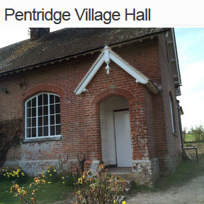
Pentridge Village Hall is the former school house. It has been recently renovated and refurbished.
For more information visit wikipedia.org.
 Pentridge Hill
Beyond the village lies Pentridge Hill a long, whaleback-shaped feature. Standing above the gently rolling chalk down lands of north-east Dorset, it is formed by a harder, more resistant band in the chalk, which also forms Windmill Hill in Hampshire, just to the east, and the more distant Gallows Hill in Wiltshire.
Penbury Knoll (606 feet), with its thicket of pines, is the highest point of Pentridge Hill. The deep coombes on either side were probably formed in the Ice Age, when they would have been filled with snow for much of the year; freezing and thawing around these patches of snow would have enlarged the Ice Age hollows to their present size. In the fields just to the east of Penbury Knoll there are numerous small, rounded flint pebbles, which indicate that the highest parts of Pentridge Hill carry an isolated capping of much younger rocks than the chalk, the Reading Beds. These pebbly sands appear at the surface in a more continuous belt to the south-east between Fordingbridge and Horton.
Woodyates
Wood Gates!
The name means "wood gates" and is believed to refer to the position of Woodyates at the entrance to the wooded area of Cranborne Chase.
The topographer James Bell described it thus in 1835 -
WOODYATES (West), an extra-parochial liberty, in the hundred of Wimborne-St-Giles, Shaston (East) division of the co. of Dorset. It consists of a single farm, and is crossed by the Roman road from Dorchester to Old Sarum.
Trafalgar history at Woodyates
The estate also contained an important coaching inn, once called the Woodyates Inn, later the Shaftesbury Arms.
On Monday 21st October 1805 the Royal Navy defeated a combined French and Spanish fleet off Cape Trafalgar on the south west coast of Spain. This victory permanently removed the threat of invasion of England. Lapenotiere landed at Falmouth on Monday 4th November 1805 and set out "express by post-chaise" for London, following what is now the Trafalgar Way. He took some 37 hours to cover the 271 mile journey, changing horses 21 times.
The 13th such change was made at the inn at Woodyates after noon on 5th November at a cost of two pounds five shillings.
On the 25th August 2005, close to the original site of The Woodyates Inn, a commemorative plaque was unveiled by The Chairman of East Dorset District Council.Diamonds & Horses
In the 18th century, Woodyates was a property of Thomas Pitt grandfather of "Pitt the Elder". He is most famous for purchase of a 410 carat (82 g) uncut diamond acquired in India and was also a member of the House of Commons.
In the 19th century, Woodyates was the site of the training establishment of William Day, who sent out the winners of many important horse races including Foxhall, winner of the Grand Prix de Paris, Cesarewitch and Cambridgeshire in 1881.
Michington
Nunnery
Michington comes from the Anglo-Saxon word for nun, 'myncheon' and the chapel of Gussage St Andrew stands on the site of a nunnery.
Time Team Visit
Minchington is an area with extensive archaeological remains and in late 2003 Channel Four's Time Team carried out a dig on Simon Meadon's land. The following article and the photograph (© Matthew Reynolds) are reproduced from the programme's web site.Brimming with remains - Archaeological work carried out on this site in the past, by the East Dorset Archaeological Society and Bournemouth University, revealed that farmer Simon Meadon's land at Minchington, Cranborne Chase, is brimming with archaeological remains. Two main areas in particular were found to contain evidence for buildings, enclosures and possibly even burials. For the last time in this series Time Team had just three days to make sense of it all.
Different periods - A large-scale geophysics survey confirmed that the landscape contained a variety of archaeological features. These turned out to be from a number of different periods. For example, trenches on the hilltop at Goldfields revealed a circular enclosure ditch, which was excavated to reveal a cross section of the ditch fill. Though no dating evidence was found, the shape of the ditch was considered to be Bronze Age. A second enclosure ditch and associated post holes were excavated that contained pottery indicating an Iron-Age date.
Cutting through the ditch feature (indicating that it was a later event) was a grave. This grave was associated with six other grave cuts, three of which were excavated. Grave goods, including a complete dimple sided pot, indicated that they belonged to relatively low status individuals of the third or fourth century AD.
Roman bath house and villa - Further geophysics surveys indicated structures in the valley bottom at Myncen Farm. Excavations here revealed the site of a Roman building, complete with a hypocaust system, a series of walls and an intact plunge pool complete with painted plaster sides relating to a bath house. The presence of a bath house indicated that an associated Roman villa complex must be nearby. Phases evident in the wall construction indicated that the building was upgraded in the third or fourth century, the same time as the burial ground was in use over the ridge.
Rebellion and revenge - Dating evidence from the site appeared to stop in the mid-fourth century AD, although many villas were occupied until the end of the fourth century and sometimes later. Guy de la Bédoyère speculated that this fact could point to a particular time in history, when Magnentius, a rebel emperor, broke away from Rome. Magnentius's rebellion, in 353 AD, was quashed and the Roman emperor Constantius II sent his imperial secretary, Paul, to Britain to sort out the situation. Paul was extreme in his revenge and many villas of sympathisers of Magnentius were destroyed. It is possible that this villa could have been destroyed at this time. Life and death in Roman Britain - The excavations at Minchington could reveal a snapshot of life and death in Roman Britain. The landscape shows a continuity of occupation from earlier prehistoric settlement. By the third or fourth century, the 'gentry' had developed their villa in the valley while the lower classes worked the land and buried their dead over the ridge.
Are the two sites related? They were certainly in use at the same time, so perhaps they were part of the same estate. One thing is certain: farmer Simon Meadon is only the latest in a long line of people who have managed and worked the landscape of Cranborne Chase.
Woodcutts
The Hamlet
Woodcutts is a small hamlet near to the Wiltshire border. It includes the site of a Romano-British settlement excavated in the 1890s.
Pitt Rivers
Much of the land around Woodcutts and several of the properties in the area belong to the Rushmore Estate. The estate formerly belonged to Augustus Pitt Rivers, a noted archaeologist of the 19th century.
Visit this site with the Time Travellers of Cranborne Chase AR app and see an augmented reality reconstruction of the settlement on the landscape.
1st Woodcutts
The 1st Woodcutts Scouts group between Woodcutts and Sixpenny Handley was founded in 1957 and provides activities for the young people of the area with Beavers, Cubs, Scouts and Explorer sections.
Find out more about the history of the group here.